Creating a custom map that is both visually pleasing and informative proved itself to be equal parts challenging and fun.
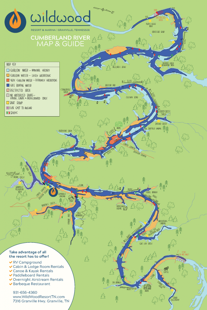
One of our clients, Wildwood Resort & Marina, shared with us a need they had for a map for boat renters. They needed more than just a map, though. Renters needed to be able to navigate the waters of the Cumberland like a local. The river is narrow, winding, and beautiful, but is also dangerously shallow in certain spots. We were able to create for them a map that not only helps boaters know where they are on the river, but where they want to hang out and where they will want to avoid.
WHAT WAS YOUR INSPIRATION?
The only assets I was given weren’t really inspiration, but more so guidelines. The US Army Corps of Engineers have free maps online that show detailed images of the river. The client was really open to giving creative liberties on this project and let me run wild with it.
WHAT WAS THE CONCEPT?
The client needed a creative way to give boat renters super valuable information. The guide needed to be bright and colorful, but also easy to read and understand.
Honestly, the tricky part of the project wasn’t even the design, but rather the production. The guide was intended to be used on the water, so it needed to be printed on a material that would withstand the water.
HOW DID YOU CREATE / EXECUTE?
My first step was to recreate the basic skeleton of the map, based off of the assets given. Once the bones of the map were there, I added in detail such as what waters were deep enough for safe boating and noted areas that were shallow and likely hazardous.
The client then took the draft of the guide, and cruised along the river. He noted landmarks that would be helpful for a boat renter who was new to the area. He even went a step further and made notes as to which areas were a little shallow or dangerously shallow.
All of this information was super helpful when color coding the river.
WHAT DID YOU LEARN? ANY OBSTACLES?
Always start larger.
With the nature of this map being 100% hand drawn, blowing it up larger wasn’t really an option. With vector artwork, the size can be easily altered without lowering the quality of the resolution. Unfortunately, I learned the hard way with this project to start bigger. Shrinking is always easier.
WHAT WERE THE RESULTS?
The end result is the most lovely map and guide, that honestly should be referred to as a work of art. This thing is so neat! It’s definitely unique and unlike any map I’ve ever seen before, featuring more pictures and less text.
The client ended up getting a large format of the map and guide printed on a weatherproof canvas for boaters and a second size printed as a large posters if visitors want to buy their own version of the map.
This was such a fun piece to get to work on, and will forever be a unique piece of art for the Cumberland River.